3D laser scanning technology, also known as real-time copying technology, is a technological revolution after the GPS technology in the field of surveying and mapping. It breaks through the traditional single point measurement method and has the unique advantages of high efficiency and high precision. 3D laser scanning technology provides 3D point cloud data for scanning the surface of an object, so it can be used to acquire high-resolution and high-resolution digital terrain models.
Principle of 3D laser scanning technologyThree-dimensional laser scanning technology is a new technology that has emerged in recent years, and it has attracted more and more attention in the research field in China. It uses the principle of laser ranging. By recording the three-dimensional coordinates, reflectivity and texture of a large number of dense points on the surface of the object under test, it can quickly reconstruct the three-dimensional model of the target and the lines, faces, and bodies. Map data.
Because the 3D laser scanning system can densely acquire the data points of the target object in a large amount, the 3D laser scanning technology is also called a revolutionary technological breakthrough from single point measurement to surface measurement compared with the traditional single point measurement.
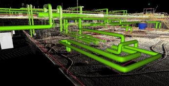
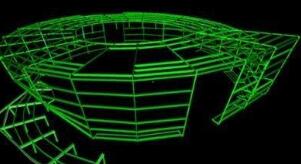
The technology has also been tried in the fields of cultural relics protection, construction, planning, civil engineering, factory renovation, interior design, building monitoring, traffic accident handling, legal evidence collection, disaster assessment, ship design, digital city, military analysis, etc. Application and exploration. The 3D laser scanning system contains the hardware part of the data acquisition and the software part of the data processing. According to different carriers, 3D laser scanning systems can be divided into airborne, vehicle, ground and handheld types.
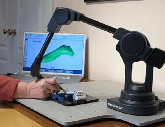
Apply scanning technology to measure the size and shape of the workpiece to work. It is mainly used in reverse engineering, responsible for surface copying, 3D measurement of workpieces, and can quickly measure the contour set data of objects in the absence of technical documents for existing 3D objects (samples or models), and construct, edit, and modify them. Generate a surface digitization model of the generic output format.
The 3D laser scanning technology has the advantages of high precision, high speed, high resolution, non-contact type, good compatibility, etc. It is praised as “another technological revolution after the GPS technology in the field of surveying and mappingâ€. Through analog analysis with traditional measurement techniques, such as total station, close-range photogrammetry, aerial photogrammetry, etc., the main features are as follows:
(1) Non-contact type. The 3D laser 3D technique uses a non-contact high-speed laser measurement method. Without the need of a reflective prism, the target body is directly depicted, and the dimensional coordinate information of the surface point of the target body is collected. In the case of dangerous targets, harsh environments, and inaccessible personnel, traditional measurement techniques cannot be completed. At this time, the advantages of 3D laser scanning technology are obvious.
(2) High degree of digitization and strong scalability. The data collected by the 3D laser 1 tracing system is digital signal, with all-digital features, easy to process, analyze, output, display, and the post-processing software user-friendly interface, can exchange and share data with other commonly used software, and can be connected with external digital The camera and GPS are used together to broaden the scope of application and have better scalability.
(3) High resolution. 3D laser 3D technology enables fast, high-quality, high-density 3D data acquisition for high resolution.
(4) Wide application and strong adaptability. Because of its good technical characteristics, it has low requirements on use conditions and strong environmental adaptability, and is suitable for field measurement. Therefore, it is widely used in various fields of engineering construction.
Virtual reality is to create as realistic 3D stereoscopic scenes and objects as possible on the basis of certain software and hardware. In virtual simulation, the realism of scenes and objects is the most critical factor. In the 1990s, virtual reality (VR) technology emerged as a new comprehensive information technology, which combined the technical branches of digital information processing, computer graphics, multimedia technology, sensor technology and other information technologies. Also born is the 3D stereo scanning technology.
As the audience's requirements for the fineness, accuracy and authenticity of the scenes displayed by virtual reality technology continue to increase, the bottlenecks of real data acquisition and fine modeling in the real world become increasingly obvious and seriously restrict the progress of virtual reality technology. . With the advent of 3D stereo scanning technology, it perfectly solves the problem of data acquisition in the real-world process of virtual reality technology.
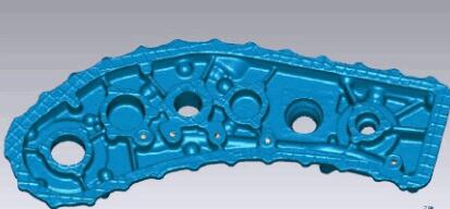
3D laser scanning technology is different from simple mapping technology (because traditional high-precision mapping technology has been used, it is enough), it is mainly for high-precision reverse 3D modeling and reconstruction, traditional mapping technology is mainly a single point accurate measurement, But when you use it for modeling work, you can't help it, because describing the complete properties of the target structure requires a large number of surveying points, ranging from tens of thousands to millions of dollars, so that the target can be completely moved to the computer. Therefore, this problem is solved by the use of modern high-precision sensing technology. 3D laser scanning technology is such a fully automatic high-precision stereo scanning technology.
The application of 3D laser scanning technology is very broad. It is a symmetric application of forward modeling (such as manual operation of CATIA, UG, CAD), so it is a reverse modeling technology (such as: directly from the physical or real scene) model).
Reverse modeling can reconstruct the changes in the process of design, production, experiment, use, etc., and then perform various structural characteristics analysis (such as: deformation, stress, performance, process, process, attitude, prediction, etc.), detection, Simulation, simulation, CIMS, CMMS, virtual reality, flexible manufacturing, virtual manufacturing, virtual assembly, etc., which are very important for software such as finite element analysis, engineering mechanics analysis, fluid dynamic analysis, etc. Post-processing mapping, measurement, etc.
In short, spatial data is a complex, interlaced, and changing attribute. The surface structure is only one of this attribute, and the task of reverse engineering will also be related to environmental quantification, virtual manufacturing, flexible manufacturing, tooling, workpiece combination, and numbers. The application of factories, process operations, visual simulation, virtual reality, etc. is expanding and expanding, and the horizontal application of society will be further expanded.
Mppt Solar Charger Controller,Wind Solar Controller,Mppt Controller,Micro Solar Charge Controller
GuangZhou HanFong New Energy Technology Co. , Ltd. , https://www.gzinverter.com