
What exactly is a superb drone?
First, what is the drone?The UAV is the Unmanned Aerial Vehicle, a non-manned aircraft that uses radio remote control equipment and self-contained program control devices, including unmanned helicopters, fixed-wing aircraft, multi-rotor aircraft, and unmanned airships. Unmanned parachute wing. Broadly speaking, it also includes adjacent space vehicles (20-100 km airspace), such as stratospheric airships, high air balls, solar drones, etc. From a certain point of view, the drone can complete complex air missions and various load tasks under unmanned conditions, and can be regarded as an "airborne robot."
According to different platform configurations, the drones can be mainly composed of fixed-wing UAVs, unmanned helicopters and multi-rotor UAVs. Other small-type UAV platforms also include UAV UAVs and flapping wings. Man-machines and unmanned spacecraft. The fixed-wing UAV is the mainstream platform for military and most civilian UAVs. The biggest feature is the faster flight speed; the unmanned helicopter is the most flexible UAV platform, which can take off and hover vertically; multi-rotor The (multi-axis) drone is the platform of choice for consumer and some civilian applications. The flexibility is between the fixed wing and the helicopter (lifting requires thrust), but it is simple to operate and low in cost.
According to different fields of use, drones can be divided into three categories: military, civilian and consumer. The performance requirements of drones are biased:
1) Military drones have higher requirements for sensitivity, flight altitude, intelligence, etc., and are the highest level of drones, including reconnaissance, decoy, electronic countermeasures, communication relays, drones, and unmanned combat aircraft. model;
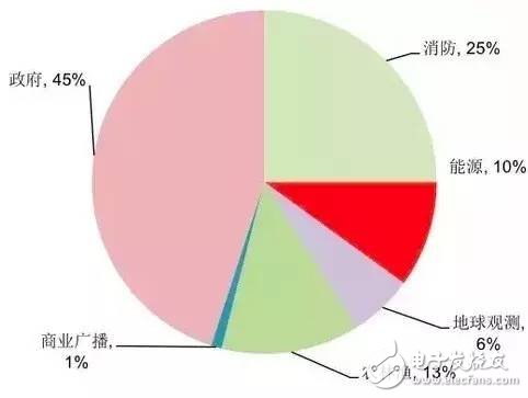
2) Civil drones generally have lower requirements for speed, ceiling and range, but have higher requirements for personnel operation training and comprehensive cost. Therefore, it is necessary to form a mature industrial chain to provide the lowest possible parts and support. Service, at present, the biggest market for civilian drones lies in the provision of government public services, such as police, fire, and meteorology, which account for about 70% of total demand, and we believe that the market with the greatest potential for future drones may In civilian use, new market demand may appear in the fields of agricultural plant protection, cargo speed, air wireless network, data acquisition, etc.;
3) Consumer-grade drones generally use low-cost multi-rotor platforms for aerial photography, games and other recreational purposes.
The world's civilian drones use the field.
Difficulties in drone technology
1. The flight control system is the "driver" of the drone - more precise and clearer
The flight control subsystem is the core system of the whole flight process of the drone to complete take-off, air flight, mission execution and return-to-field recovery. The flight control is equivalent to the driver's role for the manned aircraft. One of the most core technologies. The flight control generally includes three parts: the sensor, the onboard computer and the servo actuating device. The functions realized mainly include the three types of unmanned aircraft attitude stabilization and control, drone mission equipment management and emergency control.
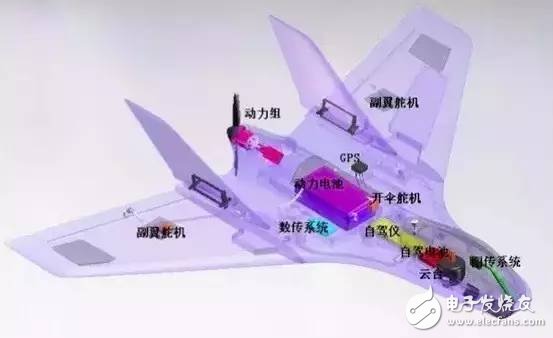
Aircraft architecture
Among them, the various sensors assembled in the fuselage (including angular rate, attitude, position, acceleration, altitude and airspeed) are the basis of the flight control system, and are the key to ensure the accuracy of aircraft control. Under different flight environments and different uses. The drone's configuration requirements for the sensor are also different. In the future, the demand for UAV situational awareness, the identification of enemy and enemy on the battlefield, and the ability of diplomatic defense in the defense zone require UAV sensors to have higher detection accuracy and higher resolution. Therefore, a large number of UAV sensors have been widely used. New technologies such as hyperspectral imaging, synthetic aperture radar, and ultra-high frequency penetration.
2, the navigation system is the "eye" of the drone, multi-technology combination is the future direction
The navigation system provides the position, speed, and flight attitude of the reference coordinate system to the drone, and guides the drone to fly according to the designated route, which is equivalent to the navigator in the man-machine system. The unmanned airborne navigation system is mainly divided into two types: non-autonomous (GPS, etc.) and autonomous (inertial guidance), but each has the disadvantage of being susceptible to interference and increased error accumulation, and the development of future drones requires obstacle avoidance, materials or The functions of weapon placement, automatic approach landing, etc. require high precision, high reliability, and high anti-interference performance. Therefore, the combination of multiple navigation technologies, "inertia + multi-sensor + GPS + photoelectric navigation system" will be the future development direction.
3, power system - turbine is expected to gradually replace the piston, new energy engine to enhance endurance
Different types of UAVs have different requirements for power units, but they all hope that the engine is small in size, low in cost, and reliable in operation: 1) The power unit widely used by drones is a piston engine, but the piston type is only suitable for low speed and low altitude. Small drones; 2) For single-use drones, suicide drones or missiles, the thrust ratio is high but the life can be short (1-2h), generally using turbojet engines; 3) low altitude unmanned helicopters Generally, a turboshaft engine is used, and a large unmanned aerial vehicle with a long-haul altitude is generally a turbofan engine (US Global Eagle weighs 12t); 4) a consumer-grade micro-UAV (multi-rotor) generally uses a battery-driven motor, take-off quality Less than 100 grams and less than one hour of battery life.
Looking forward, we believe that as the turbine engine push-to-weight ratio, life expectancy and fuel consumption decrease, the turbine will replace the piston as the main power model of the drone. New energy motors such as solar energy and hydrogen energy are also expected to be provided for small drones. More lasting viability.
4. The data link is “the line of kite flying†– the transition from a stand-alone system to a global information grid (GIG)
The data link transmission system is an important technical component of the UAV. It is responsible for completing the remote control, telemetry, tracking and sensor transmission of the UAV. The uplink data link implements the telemetry and data transmission functions for the UAV remote control and downlink data link. Ordinary drones mostly use custom line-of-sight data links, while mid-high-altitude and long-haul drones use line-of-sight and over-the-horizon data links.
The development of modern data link technology promotes the development of the UAV data link in the direction of high speed, broadband, confidentiality and anti-interference, and the practical ability of drones will become stronger and stronger. Looking forward, as the airborne sensors, the fineness of positioning, and the complexity of performing tasks continue to rise, there is a strong demand for data link loans. In the future, with the rapid advancement of airborne high-speed processors, it is expected that after several years. The transmission rate of the existing RF data link will double, and laser communication methods may appear in the future where the requirements are low in all weather.
From the development strategy of the UAV communication network developed by the United States, the data link system is being transferred from the initial IP-based transmission, multi-machine interconnection network, to the satellite network, and finally the complete global information grid (GIG) configuration transition. To provide authorized users with seamless global information resource interaction capabilities, supporting both fixed and mobile users.
Third, the development of drones
1. Military technology overflows, and the cost declines to detonate the civilian market.
War is the number one traction in the development of drones, and experienced three major technological developments at the end of the 20th century.
Undoubtedly, the early development of drones was for pure military purposes: the world's first drone developed by the United Kingdom during World War I was defined as a "flying bomb". During World War II, the Germans began to use a large number of unmanned vehicles. The bombers entered the war; the center of UAV research and development after World War II appeared in the United States and Israel. The use extended to battlefield reconnaissance and intelligence gathering. The drones were sent to North Korea, Vietnam and the Gulf battlefield to assist the US and Israeli forces. It is precisely because of the natural advantages of low-cost, flexible control and long-lasting duration of the UAV. The national military has invested heavily in the development of the UAV system.
At the end of the 20th century, drone technology experienced three development waves and truly entered the first "golden age": 1) After 1990, more than 30 countries around the world equipped with divisional (large) tactical drone systems, representatives The models include American "hunters", "pioneers", Israeli "scouts", "pioneers", etc.; 2) After 1993, military high-altitude military drones developed rapidly, with the United States "Til" no The man-machine development plan is representative and shines in the war in Bosnia and Herzegovina; 3) At the end of the 20th century, the brigade-level (small and medium-sized) fixed-wing and rotor-wing tactical drone systems appeared, which were small in size, cheaper in price, and more maneuverable. It marks the era of drones entering large-scale applications.
The early aeronautical technology solved the problem that the drone can fly. The development of modern technology since the 1980s provided conditions for the higher flight performance and better reliability of the drone. Among them: 1) Intelligent : Autonomous flight control technology and the sharply rising computer processing capability promote the development of drones to become intelligent, and truly become an "air thinking robot"; 2) High-speed bandwidth: high-speed broadband network data chain realizes unmanned unit network and interconnected, UAV grouping and air-ground equipment combination becomes possible; 3) Lighter materials and sensors: Materials science and MEMS technology further reduce the weight of the drone platform and improve accuracy; 4) Stronger endurance: battery life A sharp rise, as well as new energy technologies give drones longer flight times.
2. Technology spills into civilian use, and drone industrialization enters the era of popularization
Due to the significant advantages and flexible maneuverability of military drones in the "3D" (DULL, DIRTY, DANGEROUS) environment, the use of drones in all walks of life is also highly anticipated. However, compared with the development history of military drones in the past 100 years, civilian drones began to be applied on the basis of the great development of modern systems for military drones in the 1980s. It has only been used in all fields for more than 10 years.
Japan’s civilian drones were developed earlier: As early as 1983, Yamaha used a motorcycle engine to develop an unmanned helicopter for spraying pesticides. In 1989, it became the first unmanned helicopter to be successfully used for flight testing. In 2002, CERP Company and invented a JAXA multi-purpose civil drone; since 2003, it took 3 years, and the Industrial Association has developed 4 generations of UAV products, mainly used in forest fire prevention, earthquake disaster assessment and other fields;
NASA led the establishment of a world-class UAV application center: In 2003, NASA established a world-class UAV application center to study commercial applications with high-resolution camera sensor drones.
In recent years, the National Oceanic and Atmospheric Administration of the United States has used drones to track data related to tropical storms to improve the hurricane warning model. When the forest fire raged in 2007, NASA used Ikhana's drones to assess the severity of the fire and estimate the damage. After the explosion of the Gulf of Mexico rig in 2011, Allen Labs' drone assisted with oil spill monitoring and oil spill treatment.
Israel also specially set up a pilot committee for civil drones and their working mode. In 2008, they issued a certificate for the implementation of the "heron" UAV non-military mission, and cooperated with relevant departments to carry out a variety of civil mission test flights. .
In 2006, Europe developed and immediately implemented the “Human UAV Development Roadmapâ€. After that, the EU plans to raise a pan-European civil drone coordination organization to help solve the most critical air safety and airworthiness problems.
China started early and developed rapidly in recent years: In the 1980s, China developed its own UAVs (born out of military models) in map mapping and geological exploration. In recent years, the No. 1 drone developed for civilian use successfully made its first flight in 2010. In 2011, the domestic “bee†28 drone was fully autonomous, taking off, landing, hovering and route planning. Application of agricultural spraying, power inspection, disaster prevention and emergency response, aerial mapping, relay communication, etc.
For the civilian sector, the drone is just a flight platform, and its function is ultimately done by the task load device in the airborne system.
Compared with the rapid development of the UAV field in various industries in the ToB end, the market of ToC consumer aerial photography and entertainment in the past two years has benefited from the maturity of all aspects of the UAV technology and the significant drop in cost, which is an explosive development. Shenzhen Dajiang was established in 2006, with only a few million income in 10 years, as high as 800 million yuan in 13 years and nearly 3 billion yuan in 14 years.
3. The hardware industry chain is mature and the cost is reduced to create conditions for civil & consumer drones.
The rise of the civilian and consumer-grade UAV market in the past decade has become inseparable from the maturity of the hardware industry chain and the continuous decline in the cost curve. With the rise of mobile terminals, the industrial chains such as chips, batteries, inertial sensors and communication chips have matured rapidly. The cost reduction has enabled the intelligent process to move quickly to more compact, low-power devices. This also creates favorable conditions for the rapid innovation and cost reduction of the overall hardware of the drone:
Chip - At present, a high-performance FPGA chip can realize the dual CPU function on the drone to meet the information fusion of the navigation sensor and realize the optimal control of the unmanned aerial vehicle.
Inertial sensors - With Apple's extensive use of accelerometers, gyroscopes, geomagnetic sensors, etc. on the iPhone, MEMS inertial sensors have been on the rise since 2011, and 6- and 9-axis inertial sensors have gradually replaced individual sensors, cost and Power consumption is further reduced and costs only a few dollars. In addition, the GPS chip weighs only 0.3 grams and costs less than $5.
Wireless communication such as Wifi - communication chips such as Wifi are used to control and transmit image information, and communication transmission speed and quality can fully meet the transmission requirements of several hundred meters.
Batteries - The increasing energy density of the battery allows the drone to have a battery life of 25-30 minutes while maintaining a light weight, to the extent that it can meet some basic applications. In addition, solar cell technology enables high altitude drones. Sustainable flight for a week or more.
Cameras, etc. - In recent years, mobile terminals have also promoted the dramatic increase in performance and cost of lithium-ion batteries and high-pixel cameras.
4, the flight control system is open source, the drone flies into the home of ordinary people
If the hardware cost reduction solves the problem of the "body" of the drone, in recent years, the trend of the open source of the flight control system has solved the problem of the "brain" of the drone. From then on, the drone is no longer a patent of military and scientific research institutions. Commercial enterprises and enthusiasts all over the world have joined the tide of drone system design, which is the "explosion point" for detonating the civilian and consumer drone market.
Germany MK company is the originator of multi-rotor UAV system open source. Later, in 2011, American APM company opened the drone design platform to completely ignite the market's enthusiasm for the development of UAV systems. After 2012, civilian and consumer drones entered. The channel that accelerates the uplink.
Up to now, the international drone industry has formed five major drones such as APM (most users), German MK (the earliest open source system), Paparazzi (high stability, strong scalability), PX4 and MWC (strong compatibility). platform.
Taking PPZ (Paparazzi) as an example, PPZ, which started in 2003, is a software and hardware open source system. So far, it has formed a full set of mature solutions covering not only sensors, GPS, autopilot software, but also ground equipment. Fixed-wing aircraft can also drive gyroplanes, and satellite maps of aircraft flight can be monitored in real time through ground control software. It can be said that the powerful open source flight control system has made the drone fully enter the "user friendly" era.
In October 2014, the famous computer open source system company Linux launched a drone-based open source system cooperation project called "Dronecode", which included 3D Robotics, Intel, Qualcomm, Baidu and other technology giants into the project team, aiming to be a drone. Developers provide the resources, tools, and technical support needed to accelerate the development of the UAV and robotics arena. According to a report by Teal Aviation Market Research, the Dronecode project brings the total value of R&D, testing and evaluation of the world's drones to $91 billion over the next decade. The Dronecode development interface includes unmanned off-road vehicles, unmanned fixed-wing aircraft, unmanned helicopters and various multi-axis rotorless drones. It absorbs multiple platforms such as APM and PX4, further promoting the visualization and friendliness of system development. .
UAV-related policies: National policies are in continuous improvement
China's drone related policies: stepping out of the first step of standardization
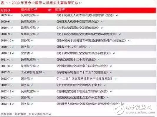
Summary of major government related drones in China since 2009
In general, before 2009, drones were in an unregulated gap. Since 2009, it has entered the stage of certification flight, but the laws, regulations and supervision have not been perfected and formalized, and the actual application operation is ambiguous.
US drone related policy: commercial drone draft
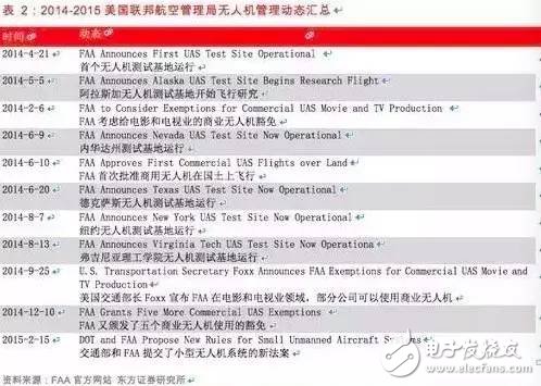
2014-2015 US Federal Aviation Administration drone management dynamic summary.
After a long wait and several extensions, on February 15, 2015, the US Federal Aviation Administration finally announced the long-awaited draft of the drone business management method. This new rule broke the previous comprehensive no-fly situation, but it has yet to be finalized.
This rule is mainly applicable to drones weighing less than 25 kg. The main limitations include:
(1) Flight time, high speed, speed, and loading restrictions: It limits the drone to fly only during the day, and must remain within the operator's line of sight throughout the journey. The flight altitude must not exceed 150 meters and the speed should not exceed 160 kilometers per hour. Do not fly over the top of the head, do not throw things from the drone, and do not hang the parcel on the outside of the body.
(2) Flight route location restrictions: UAVs must avoid aircraft flight routes and flight restrictions, and must strictly comply with the relevant temporary flight restrictions. Unmanned aircraft should avoid at least eight kilometers of the airport of the manned aircraft. When the unmanned aircraft is flying, it should always be within the radio operator's horizon.
(3) Driver qualification requirements: The drone operator must be at least 17 years old, and must obtain the FAA drone operator qualification certificate and pass the TSA (American Transportation Security Administration) review requirements.
(4) In addition, the model drone about the hobbyist is still as unrestricted as before, as long as it does not hinder air traffic.
British drone policy: the world's drone regulations leader
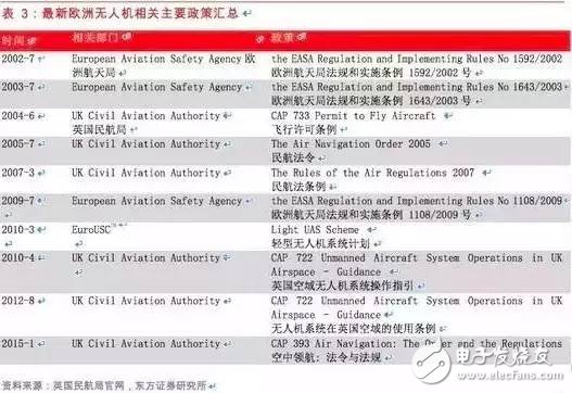
Summary of the main European drone related policies
CAP722 is the British Civil Aviation Authority's guidelines for the use of drones in British airspace. The fourth edition of CAP722 was released in April 2010 and has been adapted to the launch of Air Navigation Act 2009. All regulations on drones are now included in Air Navigation Act 2009. Prior to that, CAP722 was the industry's reference standard and was modeled and implemented by the world. This document highlights the safety requirements for airworthiness and operational standards that need to be addressed before operating a drone in the UK. The latest version of cap722 was released in August 2012 and has a fairly open policy on civilian drones. The British Civil Aviation Authority is the leader in the field of drone regulations.
European Regulations 2008 No. 216 regulates all drones with a total weight of more than 150 kg. The design and production of drones must also comply with the relevant certification regulations as with conventional aircraft (the norm is led by EuroUSC, which obtains civil aviation) The Bureau is authorized to implement the Light UAV program and must obtain airworthiness certification or a quasi-flying permit. In the UK, drones weighing between 20 kg and 150 kg are required to have airworthiness qualifications under UK law. The aircraft is in the range of 500 meters and below 400 feet or in isolated flight areas, and the drone and the flight have certain airworthiness guarantees, the British Civil Aviation Authority can exempt the need for airworthiness certification. British Civil Aviation Authority Immunities will also be granted on the basis of their own investigations and recommendations. Currently only one organization has obtained this license. The drones with a weight of less than 20 kg do not need to comply with many major policy requirements, but the pilot law is 98th. Some conditions have been set in the text. These conditions include prohibiting flights in or near the restricted area, unless permitted by the Air Traffic Control Authority, at a maximum altitude of 400 feet and prohibiting high altitude operations without the special permission of the British Civil Aviation Authority.
Currently, the British Airways Act does not require a pilot pilot to operate the drone. However, the British Civil Aviation Authority requires all potential drone controllers to master flight qualifications. Flight qualifications are available through the completion of a designated course, and four certification bodies operate training and exams.
UAV global market
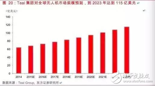
The above picture shows the Teal Group's forecast of the size of the global drone market. They expect the drone market to reach $11.5 billion by 2023.
For the military and civilian market share, TealGroup gives a more optimistic judgment on the civilian market (about 9% of the annual compound growth rate, reaching $1.5 billion by 2023, of course, TealGroup specifically mentioned Google in the report. The subversive changes that the high-tech giants such as Facebook and Amazon have brought to the civilian military drone industry are now difficult to quantify.
We believe that the two bottlenecks that need to be broken through the explosive growth of the civil drone market worldwide are airspace resources and security issues. Once these two problems are solved worldwide, humans use drones to conquer the imagination of airspace. Will be completely opened, the global civil drone market may show explosive growth.
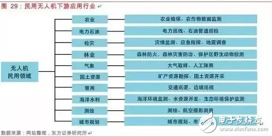
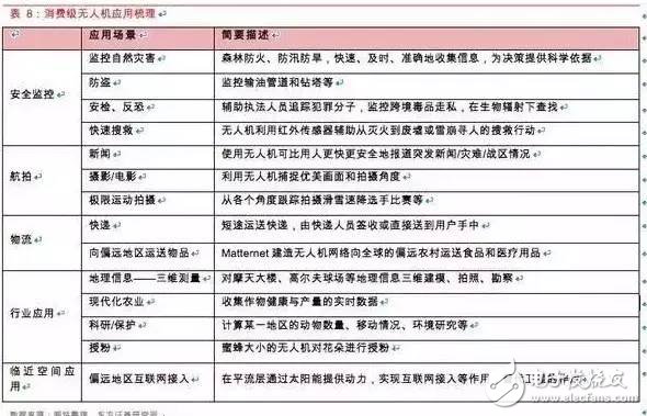
Civil drone downstream application industry
The downstream demand for civil drones is very extensive, including agriculture, power oil, disaster detection, forestry, meteorology, land and resources, police, marine water conservancy, surveying and mapping, and urban planning. In recent years, the application of drones in the civilian market has received more and more attention. For example, in the fields of agriculture and forestry plant protection and power inspection, the demand for drones is more urgent and has a larger market scale. We believe that the potential demand of other industries will gradually emerge. The space of our national drone market is huge and will enter a period of rapid development.
Agricultural plant protection: the largest market for civilian drones, the scale of agricultural plant protection market exceeds 10 billion
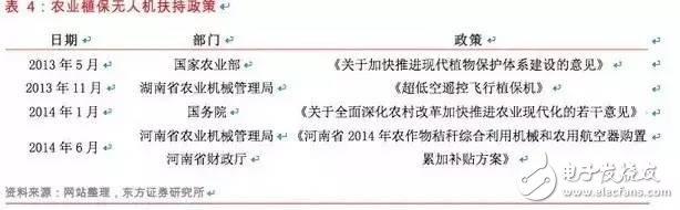
Japanese plant protection drones have been in use for more than 20 years and currently have an annual update of approximately 3,000. According to the calculation of pesticide use in China and Japan, if China reaches the current penetration rate and frequency of use of plant protection drones in Japan, the annual update volume is about 30,000, and the price of plant protection drones is calculated at 500,000 yuan/frame. The annual market size can reach 15 billion yuan.
Power inspection: policies are expected to be introduced, the market scale is over one billion
In January 2009, State Grid Corporation officially established an unmanned helicopter inspection system.
In March 2013, the State Grid Corporation of China issued the “Pilot Work Plan for Helicopter, UAV and Manual Collaborative Inspection Mode of Transmission Lines of State Grid Corporationâ€. The program pointed out that the establishment of a new type of inspection mode for helicopters, drones and manual inspections is an urgent need for the development of smart grids. At present, the company's system helicopter inspection operations are gradually developing towards standardization and institutionalization. Ten maintenance companies in Shandong, Weibei, Shanxi, Hubei, Sichuan, Chongqing, Zhejiang, Fujian, Liaoning and Qinghai were used as pilot units to carry out pilot projects for new patrol modes in 2-3 years. By 2015, the State Grid Corporation system will fully promote the new patrol mode of transmission lines that cooperate with helicopters, drones and manual inspections.
In June 2014, the Standardization Center of the China Electricity Council announced the draft of the power industry standard called “Technical Guidelines for Inspection of Unmanned Aerial Vehicles for Overhead Transmission Lines†and publicly solicited opinions. We expect the UAV industry standard for the Power Union to be officially introduced this year.
China's 110kV high-voltage transmission line is about 520,000 kilometers. According to the annual inspection frequency of 30 times, the total inspection length is about 15.6 million kilometers per year. The drones are inspected for 20 kilometers per hour, and the annual flight time of the single aircraft is calculated according to 150 hours. The country needs 5,200 aircraft. Calculated on the basis of RMB 200,000 per piece, the annual market space is about 1.04 billion yuan.
Forest fire prevention: urgent demand, still in the initial stage
China has a forest area of ​​175 million hectares, a forest stock volume of 12.456 billion cubic meters, and a forest coverage rate of 18.21%. It is both a forest resource country and a forest fire-prone country.
At present, many new technologies and new equipments have been applied in forest fire prevention in foreign countries. The domestic demand for applications in this area is also increasing. The investment in forest protection is gradually increasing. Satellites are used for resource surveys and forest fires. The monitoring of forest fires by the drone system is still the initial stage.
Disaster inspection: national conditions need, space is vast
In 2008, the Wenchuan earthquake triggered a number of secondary geological disasters such as collapse, landslides, mudslides, and dammed lakes, causing serious damage to most national roads, provincial roads, and rural roads in the disaster area, making it difficult to imagine disaster relief work. Due to the influence of weather factors, it is difficult for satellite remote sensing systems or manned aerial remote sensing systems to obtain real-time ground images of the disaster areas in time. After the earthquake, various types of UAV aerial remote sensing systems quickly entered the disaster area, and were widely used in disaster investigation, landslide dynamic monitoring, housing and road damage assessment, disaster relief effect evaluation, disaster area restoration and reconstruction, etc. The effect has played a role that cannot be replaced by other means. The first large-scale use of the UAV airborne remote sensing system for emergency response was successful.
During the search and rescue of the Ya'an earthquake in 2013, the National Earthquake Disaster Emergency Rescue Team used the rotary wing drone to conduct aerial inspections of the terrain and damage of the disaster area, providing a reference and basis for the search and rescue work of the National Earthquake Disaster Emergency Rescue Team. The UAV was jointly developed by the National Earthquake Disaster Emergency Rescue Team and the Shenyang Institute of Automation, Chinese Academy of Sciences, and used in the seismic search and rescue process. The detection accuracy is 0.1 meters, and it can fly 100 kilometers continuously at a low altitude of 200 meters.
Natural disasters occur frequently in China, and the losses caused by disasters every year are enormous. In the event of a disaster, timely and accurate disaster information must be provided in order to improve the efficiency and quality of disaster relief. The conventional disaster monitoring method has a long cycle and high cost, and it is difficult to meet the needs of disaster relief. As a supplementary means of satellite remote sensing and manned aerial remote sensing, UAV aerial remote sensing system has the advantages of strong real-time, flexible and convenient, small external environment impact and low cost. It has broad development space and application prospects in disaster emergency rescue. .
2. The consumer drone market is heating up rapidly
This year, the global drone market has attracted wide attention. Dajiang's innovative products are coming to the forefront. Domestic products such as Feifei Technology, Zero-Intelligence Control, and foreign 3DRobotics are constantly expanding their products and financing activities. In 2015, they can be said to be consumer drones. The first year.
DJI Innovation is the world's leading small unmanned aircraft manufacturer, accounting for about 50% of the global civilian small drone market share, 80% of the company's products are sold abroad. An invisible world-class drone company that Silicon Valley believes can be compared to Apple. Founded in 2006, the company initially cut in from controllers installed on drones, and then found market access points for unmanned aerial vehicles aerial photography, turned into complete machines and stable flight platforms, and high-definition digital video transmission modules, and now Committed to providing a complete flight imaging strategy. In just a few years, it has grown by a thousand times. In 2013, its revenue reached 800 million yuan. It was named the top ten innovation tools in 2014 by the US magazine Time magazine.
DJI drones in DJI are widely used in aerial photography and are very popular among professional and amateur photographers. Its product line covers the mid-range Phantom (the Great Elves) and the Inspire ("Wu") series of the absolute king of the high-end market. Including the hit TV show "Dad, Where to Go", as well as aerial photography in the popular US dramas such as SHIELD agents and homeland security. It is also used by users to scan the image of Christ in Rio de Janeiro, close to the whales, and the volcanic Isul.
In addition to the innovation of Dajiang, in recent years, domestic and foreign technology companies have heated up their attention to drones. The drones are not only the "toys" of aerial photography, but also the robots that subvert the future: Amazon's PrimeAir man-machine logistics plan has entered The 9th generation of research and development; Google acquired the drone company TitanAerospace to provide network coverage; Facebook also acquired the British drone company Ascenta for 20 million US dollars; 3DRobotics drone has been invested by its $50 million investment; Maternet built The drone network delivers food and medical supplies to remote rural areas around the world.
The domestic drone market has gradually emerged, and similar technologies such as Dajiang Science and Technology, Zero Intelligence Control, Extreme Flying Technology, Yidian Technology, Yihang UAV, Tianxiang UAV, etc. have been born. On January 20, 2015, Leibai Technology and Zero Intelligence jointly set up a joint venture company to develop drones. On February 1, 2015, the two parties released the ZERO consumer-grade quadrotor UAV series products, and the official website and partial electricity in Shenzhen. The business platform began to pre-sale, starting at 3199 yuan.
At present, drones are mainly used in various industries such as aerial photography, including border defense and agriculture. For example, Dajiang Innovation is mainly used for aerial photography, and Feifei Technology is used in various industries. In addition, search and rescue, anti-theft and other security monitoring applications are also starting. There are more and more attempts to use drones for logistics. Amazon has been researching and developing for many years, and the domestic express delivery industry has begun to test the water.
Google Lobster Project Loon is preparing to build a network of stratospheric balloons around the world, and then acquire Titan Aerospace to provide solar-powered drones, both of which provide low-cost, global coverage of the entire planet. In.
NASA is also developing a drone "low-altitude traffic management system" that is expected to be used in agriculture in 2015. UAV manufacturer Skycatch, which specializes in data collection for the construction, mining, solar, and agricultural industries, has previously secured $13.2 million in financing. Other innovative applications include bee-sized drones that pollinate flowers and more.
GoPro also joined the "Small UAV Alliance" last year, and has already launched video camera equipment for a variety of drones. GoPro also announced that it will enter the consumer-grade UAV field, and is expected to officially launch the first multi-motor drive this year. The drone will be priced between $500 and $1,000. DJI also announced that it will adopt a self-developed camera for future UAV products. The combination of drones and motion cameras will be an important application for drones in the field of personalized aerial photography such as sports health, such as STELLA's stable pan/tilt designed for GoPro Hero3 series cameras.
UAVs can be used with Oculus Rift to get a virtual reality and augmented reality experience. For example, Parrot launched the wireless control accessory Skycontroller, connected to the Oculus Rift with HDMI interface, can directly control the flight of the aircraft, and use the up, down, left and right buttons to control the running track of the aircraft. Bring people's perceptions to another real space with the help of "connection". Such an experience may be applied to tunnels, canyons and underwater scenes in the future, and explorers will no longer need to experience and experience a thrilling sensory experience. More importantly, he does not need to use human and material resources to model and create a virtual world, and any location can become a new playground.
According to Dajiang Innovation's revenue of about 3 billion yuan last year and the price of thousands to tens of thousands of yuan, the number of drones shipped is hundreds of thousands, and there is great room for growth in the future. According to TealGroup statistics, the global civilian drone market has reached 2.8 billion U.S. dollars in 2014, and will continue to grow in an unprecedented way in the next 10 years, and the market size will more than double.
5. In the future, what can UAVs do for us?
In addition to the military, commercial, and consumer functions we already know, the future of drones that can “go to the sky†may bring infinite surprises to our lives. At a height of 300 meters, there is no ground crowding and various restrictions. In the future, drones can not only play the role of super courier and super police, but also provide low-cost, highly mobile wireless coverage for the ground. Think of the drone as a "flying sensor", the drone becomes an air data port of Industry 4.0, as far as geophysical, meteorological, agricultural data, small to personal location information, the drone will detonate an empty space The big data revolution in!
1. The air data port of Industry 4.0!
We believe that as a "flying sensor", the most imaginative application of drones in the civilian field in the future may be as a data port in the air, providing more accurate and powerful for the industrial 4.0 "big data" system connecting the world. The data stream.
Starting from the most common inspection function of drones, using drones to patrol farmland nationwide, it is possible to observe information on crop growth, natural disasters, soil changes, etc. more clearly than satellite images. Linked to the global Internet, the collected data can be transmitted to commodity analysts in real time to judge the global crop futures market trend; in the future precision agriculture system, small drones can be used to observe whether the crop is short of water, information Feedback to the irrigation system to regulate the amount of water.
From the acquisition of personal information data, the drone can simulate the WiFi hotspot, sniff the MAC address of the mobile device, and triangulate the device according to the strength of the signal, etc., and collect the collected information to draw the user's motion map. , showing the blocks, shops, etc. that he usually passes by, and then conditionally screening users, such as pushing promotional information to potential consumers who “go through the doorâ€. By tracking the individual's trajectory, you can more fully grasp the living habits of the crowd and provide more accurate reference data for the manufacturer. In addition, in an emergency, you can save lives by locating mobile devices. The drone uses the Wi-Fi signal of the victim's mobile phone to determine the location of the trapped person.
This technology is similar to the indoor mobile device positioning technology commonly used in shopping malls and supermarkets, such as iBeacon, which can push promotional information when users pass by. The difference is that drones are more flexible and can locate users in more complex geographic conditions.
2. The next stop of the technology giant: providing flexible, low-cost WIFI network access
Nearly four billion people in the world still have not connected to the Internet. How to solve Internet access problems, such as WiFi network deployment, has become one of the top ten solutions for human beings.è€Œæ— äººæœºçš„èƒ½è€—è¾ƒä½Žï¼Œä½†é£žè¡Œæ—¶é—´å´è¾ƒé•¿ï¼Œå¯ä»¥ä¸ºæ›´å¤§èŒƒå›´å†…的用户æ供互è”网接入æœåŠ¡ã€‚åŒæ—¶æ— 人机具有很强的机动性,å¯ä»¥æ ¹æ®æŸä¸€åŒºåŸŸå†…的特殊需è¦æ¥æ供互è”网接入æœåŠ¡ã€‚
Google收è´Titanï¼Œç”¨æ— äººæœºæŠ¢å 互è”网覆盖市场:在2014å¹´4月份收è´äº†æ— 人机公å¸Titan Aerospace。Titan Aerospaceæˆç«‹äºŽ2012å¹´ï¼Œå…¶æ— äººæœºè¯•å›¾å–代高æˆæœ¬çš„近地å«æ˜Ÿã€‚ç›®å‰å·²ç»ç ”制æˆåŠŸå¹¶å¼€å§‹æµ‹è¯•æ— 人机Solara50å’Œ60,å¯ä»¥é€šè¿‡å¤ªé˜³èƒ½è¡¥å……动能,在近地轨é“æŒç»èˆªè¡Œäº”年而ä¸ç”¨é™è½ã€‚Solaraæ— äººæœº50米宽,å¯ä»¥æ‰¿è½½32kg,速度达到104km/h,Titanè¡¨ç¤ºé€šè¿‡ç‰¹æ®Šè®¾å¤‡ï¼Œå…¶é«˜ç©ºæ— äººæœºæœ€é«˜å¯æä¾›æ¯ç§’高达1GB的网络接入æœåŠ¡ã€‚
æ®ç§°åœ¨æ”¶è´ä¹‹åŽï¼ŒTitan Aerospace将会与Google的两个项目进行åˆä½œï¼Œå…¶ä¸ä¹‹ä¸€æ˜¯é€šè¿‡é«˜ç©ºæ°¦æ°”çƒæ供互è”网æœåŠ¡çš„ProjectLoon,除æ¤ä»¥å¤–,Google还计划斥资10亿美元,用å«æ˜Ÿæ供互è”网覆盖。氦气çƒã€æ— 人机与å«æ˜Ÿä¸‰ç®¡é½ä¸‹ï¼Œå†åŠ 上在城市推进的有线光纤接入Google Fiber,å¯è§Google对互è”网入å£çš„é‡è§†ç¨‹åº¦ã€‚
ä¸è¿‡ï¼Œæœ‰çº¿æŽ¥å…¥æ˜¯åœ¨å·²æœ‰è¦†ç›–地区æ供更优质的æœåŠ¡ï¼Œè€Œå‰ä¸‰ç§æ— 线接入方å¼ä¸»è¦è§£å†³çš„æ˜¯è¦†ç›–é—®é¢˜ã€‚ä½†ç›¸å¯¹è€Œè¨€ï¼Œæ— äººæœºæŠ€æœ¯å¯èƒ½ä¼šæ¯”氦气çƒæ›´æœ‰ä¼˜åŠ¿ï¼Œå› 为Titan Aerospaceçš„æ— äººæœºé‡‡ç”¨å¤ªé˜³èƒ½æ供动力,ç»èˆªèƒ½åŠ›å¯é•¿è¾¾ä¸€å¹´ï¼Œè€Œæ°¦æ°”çƒçš„部署æˆæœ¬å¤ªé«˜ï¼Œç»´æŠ¤éš¾åº¦ä¹Ÿç›¸å¯¹è¾ƒé«˜ï¼›æ¤å¤–ï¼Œæ— äººæœºçš„å…¶é£žè¡Œé«˜åº¦æ—¢é«˜äºŽå•†ä¸šé£žæœºçš„æµ·æ‹”ï¼Œåˆä½ŽäºŽå«æ˜Ÿçš„高度,使得它å¯ä»¥ç¨³å®šæä¾›1Gbps的高速接入。所以未æ¥Googleçš„æ— äººæœºå¯èƒ½ä¼šåœ¨å°èŒƒå›´å†…æ供大容é‡æœåŠ¡ï¼Œè€Œå«æ˜Ÿåˆ™ç”¨äºŽä¿è¯ä½Žé€ŸçŽ‡éœ€æ±‚地区的覆盖。
Facebook为了下一个10äº¿çš„ç”¨æˆ·ï¼Œç”¨æ— äººæœºè¦†ç›–å远地区
Facebookæˆç«‹äº†Connectivity Lab(连接实验室),其使命就是开å‘包括å«æ˜Ÿã€æ— 人机在内的å„自互è”网连接技术。Facebookå·²ç»ä»¥2000万美金收è´å¦ä¸€å®¶æä¾›ç±»ä¼¼æŠ€æœ¯çš„æ— äººæœºäº§å•†Ascenta。Ascentaçš„å¤ªé˜³èƒ½æ— äººæœºä¸€æ¬¡ä¸Šå¤©å¯ä»¥åœ¨20km高空æŒç»é£žè¡Œï¼Œæ»žç©ºæ—¶é—´é•¿è¾¾1个月。Facebookæ¶‰è¶³æ— äººæœºä¸»è¦ä¹Ÿæ˜¯ä¸ºäº†æ供网络æœåŠ¡ã€‚为å远地区居民æä¾›å¯ç”¨çš„网络æœåŠ¡ï¼Œä»¥è¯•å›¾èµ¢å–了下一个10亿用户。
3ã€ä¼šé£žçš„é…é€å¿«é€’员
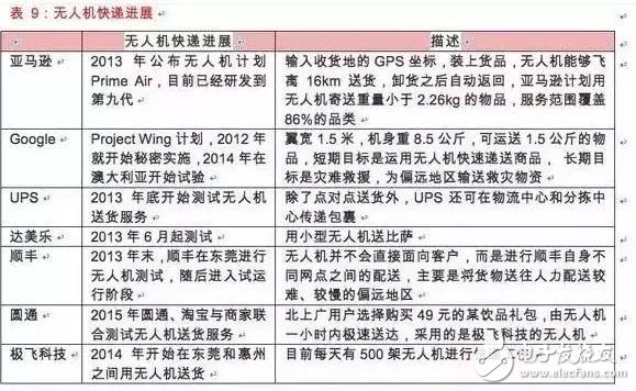
æ— äººæœºé€è´§æœåŠ¡æœ€è‘—åçš„è¦æ•°äºšé©¬é€Šçš„Prime Airæ— äººæœºç‰©æµè®¡åˆ’,2013年底,亚马逊公布了一款å«Prime Airçš„8ç¿¼æ— äººæœºï¼Œèƒ½å¤Ÿè¿è¾“一件五磅é‡çš„快递。Amazon现在ä¾ç„¶è‡´åŠ›äºŽè´ç‰©é¢†åŸŸï¼Œç»™ä¸Žç”¨æˆ·æ— 穷的选择ã€æœ€ä½Žçš„ä»·æ ¼ï¼Œä»¥åŠæœªæ¥å°†è¦å®žçŽ°çš„å³æ—¶é€è¾¾ã€‚现在,亚马逊的Prime Airå·²ç»è¿ä»£è¿›å…¥ç¬¬ä¹ä»£ï¼Œå¯è´Ÿé‡5磅货物,而这个é‡é‡è¦†ç›–了86%çš„å“类,åŒæ—¶èƒ½å¤Ÿè¾¾åˆ°è¶…过50英里/å°æ—¶çš„速度飞行。已ç»æ£å¼å‘FAA申请更大范围的室外飞行测试。å¦å¤–Googleã€UPSç‰ä¹Ÿä»Ž2012-2013å¹´å°±å¼€å§‹æµ‹è¯•æ— äººæœºé€è´§ã€‚
éšç€å¤§ç–†ç‰å‡ åƒå…ƒé«˜æ€§èƒ½æ— äººæœºçš„æŽ¨å‡ºï¼Œæ— äººæœºå¿«é€’å¯ä»¥å¤§å¤§é™ä½Žâ€œæœ€åŽå公里â€çš„物æµæˆæœ¬ï¼š
能耗æ¯å•ä¸åˆ°0.1元——以载é‡ä»¥2公斤计算,包裹10km范围内直接硬件æˆæœ¬ï¼ˆä¸»è¦æ˜¯èƒ½è€—)ä¸åˆ°0.1元,æ¯å•è€—电10Ah,ä¸åˆ°40Wh,耗电约0.03元;
æ— äººæœºæ‘Šé”€æˆæœ¬â€”—以一个5000å…ƒçš„æ— äººæœºæµ‹ç®—ï¼Œ5å¹´çš„è¿è¥å¯¿å‘½ï¼ŒåŠ 上æ¯å¹´20%的维护费,约6000元,4å…ƒ/天,如果æ¯ä¸ªæ— 人机æ¯å¤©å®Œæˆ10次任务,这就æ„味ç€æ¯ä¸ªåŒ…裹摊销æˆæœ¬0.4元;
åˆè®¡æ¯å•ä¸åˆ°0.5元的æˆæœ¬ï¼Œç›¸æ¯”ç›®å‰çš„人工物æµæˆæœ¬æœ‰æ˜Žæ˜¾é™ä½Žï¼Œå› æ¤ä»Žç»æµŽæˆæœ¬æ¥çœ‹ï¼Œæ— 人机é€è´§å…·å¤‡æ˜Žæ˜¾çš„ç»æµŽæ•ˆç›Šã€‚
æ— äººæœºç‰©æµæœ€å›°éš¾çš„是最åŽçš„货物投é€é˜¶æ®µï¼Œä»…知é“目的地的GPSåæ ‡æ˜¯è¿œè¿œä¸å¤Ÿçš„。目å‰æ¾³å¤§åˆ©äºšå…‹æž—é¡¿å’Œæ ¼å…°ç‰¹çš„æ–¹æ³•æ˜¯åœ¨æ— äººæœºä¸ŠåŠ è£…æ‘„åƒå¤´ï¼Œå¹¶åœ¨ç”¨æˆ·çš„阳å°ä¸Šæ”¾ä¸€ä¸ªå¤§ç›’åï¼Œä¸Šæœ‰ç‰¹å®šæ ‡è¯†ï¼Œæ— äººæœºé€šè¿‡æœºå™¨è§†è§‰è¯†åˆ«å¹¶å‡†ç¡®æŠ•é€’åˆ°ç”¨æˆ·çš„é˜³å°ä¸Šã€‚
æ¤å¤–,法规ä»ç„¶æ˜¯æœ€å¤§é˜»ç¢ã€‚近期美国è”邦航空管ç†å±€ï¼ˆFAAï¼‰å…¬å¸ƒæ— äººæœºç®¡ç†çš„新法è‰æ¡ˆï¼Œ
在FAAæ议的新规则ä¸ï¼Œè¦æ±‚æ— äººæœºå¿…é¡»åœ¨æ“作者视线内。主è¦æ˜¯é™åˆ¶å•†ä¸šæ— 人机用于摄影ã€å‹˜å¯Ÿçº¿è·¯ã€æœæ•‘以åŠç›‘控作物ç‰ï¼Œå¯¹äºŽæ— 人机物æµæœåŠ¡ä¸åˆ©ã€‚
4ã€ä¸ªäººå®‰å…¨çš„空ä¸å®ˆæŠ¤è€…
æ— äººæœºå·²å…·å¤‡ç‰©æµé€è´§ã€ç›‘测信æ¯ã€èˆªç©ºæ‹æ‘„ç‰å„ç§åŠŸèƒ½ï¼Œé‚£ä¹ˆèƒ½å¤Ÿè®°å½•æˆ‘ä»¬æ—¥å¸¸ç”Ÿæ´»çš„æ— äººæœºçš„è¯žç”Ÿæ˜¯å¦ä¹ŸæŒ‡æ—¥å¯å¾…了呢?或许在ä¸ä¹…çš„å°†æ¥å°±èƒ½å¤Ÿæˆä¸ºçŽ°å®žï¼Œä½äºŽä¸Šæµ·çš„AirMindå…¬å¸å¼€å‘出的“Mind4â€å››æ—‹ç¿¼æ— äººæœºè¢«æŽˆäºˆäº†â€œè·Ÿè¸ªè€…æ— äººæœºâ€çš„称å·ï¼Œå› 为它具有跟踪æŸä¸€æŒ‡å®šäººç‰©æˆ–ç›®æ ‡å¹¶å¯¹å…¶è¿›è¡Œæ‹æ‘„的功能。
'Mind4'的设计ç†å¿µæ˜¯ä¸ºäº†è®°å½•æˆ‘们的生活,甚至是记录éžäººç±»ç”Ÿç‰©ã€‚“Mind4â€é…备的摄åƒå¤´èƒ½å¤Ÿè¦†ç›–到è·ç¦»æŒ‡å®šç‰©ä½“20米以外的地方。å‡å€Ÿå…¶è‡ªåŠ¨å¯¼èˆªåŠŸèƒ½ï¼Œâ€œMind4â€è·Ÿè¸ªé€‰å®šç›®æ ‡æ—¶çš„最大高度å¯è¾¾20米,最远身åŽè·ç¦»å¯è¾¾50米。而且还能通过手势对其进行控制。
é…备有内置摄åƒå¤´çš„å››æ—‹ç¿¼æ— äººæœºå¦‚ä»Šå·²ç»å¹¿æ³›æ™®åŠï¼Œä½†å¤§éƒ¨åˆ†æ— 人机ä»éœ€è¦å¯¹å…¶è¿›è¡Œè¿œç¨‹é¥æŽ§ã€‚基于GPSçš„è¿½è¸ªæŠ€æœ¯æ— æ³•ç¡®ä¿ç‰©ä½“所处方ä½ï¼ˆå³æ‘„åƒå¤´æŒ‡å‘çš„ä½ç½®ï¼‰çš„ç²¾ç¡®æ€§ï¼ŒåŽŸå› åœ¨äºŽæ°‘ç”¨GPS通常情况下都ä¸ç²¾ç¡®ã€‚
考虑到这些年æ¥æ°‘ç”¨æ— äººæœºäº§å“的快速å‘展,åƒâ€œMind4â€è¿™ç±»äº§å“的诞生也许已ç»ä¸è¶³ä¸ºå¥‡äº†ã€‚未æ¥æ›´åŠ æˆç†Ÿçš„å¯è·Ÿè¸ªè®°å½•æŒ‡å®šç›®æ ‡çš„æ— äººæœºå¯å¯¹ä¸ªäººå®‰å…¨å®žçŽ°å…¨é¢çš„监测和ä¿æŠ¤ã€‚试想一下:未æ¥ä½ çš„å©å上å¦æˆ–玩è€æ—¶ï¼Œä¼šæœ‰ä¸€æ”¯æ— 人机舰队éšæ—¶è·Ÿè¸ªæ‰«æå±é™©ï¼Œä¿æŠ¤ä»–的安全。
SHENZHEN CHONDEKUAI TECHNOLOGY CO.LTD , https://www.szfourinone.com